In this section, we will present a brief sketch of the hydropolitics involved in the water resources of the Jordan Basin, together with some references to literature.
[UNDER CONSTRUCTION: more information needs to be added to explain the situation on the ground; e.g. separate pages on the National Water Carrier, the King Abdullah Canal, the situation on the border of Israel-Lebanon-Syria, the Israeli-Jordanian peace agreement of 1994, the agreements between Israel and the Palestinian Authority; Links to locations on satellite imagery and other illustrations; Literature references]
The hydropolitics and withdrawal of water from the river are a key feature in the geopolitical constellation of this region, which incudes the continuing belligerent situation between Israel and Lebanon and Israel and Syria since 1948, the annexation of the Syrian Golan Heights by Israel, the occupation of the Palestinian West Bank by Israel and its policy of settlement and appropriation of agricultural land, and the relations between Jordan and Israel based on the 1994 peace agreement.
Upper Jordan sub basin
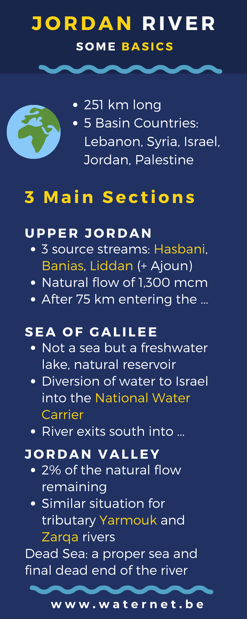
Usually, three streams are identified as the sources of the Jordan River: Hasbani, Banias and Liddan (Dan).
- The Hasbani is a seasonal stream. Its spring is located near the town of Hasbaya in the south of Libano; a quick look at images from Google Earth also learn that it is fed by surface water from the slopes of the Mountain of the Sheikh (Jabal al Sheikh, Mount Hermon). The Hasbani flows southwest and southwards from Hasbaya, follows the Syrian-Lebanese border from the town of Ghajar and then after a few kilometers crosses into Israel. The eastern shore at Ghajar is part of the Golan Heights territory, occupied by Israel since the war of 1967 and formally annexed in 1981. Just north of Ghajar, in Lebanon, the Hasbani is joined by the Wazzani, a permanent stream over which an incident emerged in the summer of 2002 - as an illustration of the sensitivity of the geopolitics of water.
- The sources of the Banias are located on the Syrian Golan Heights. Israeli annexation of the territory gives it full control over surface water and groundwater resources that feed the sources of the Banias. Settler communities exploit the water for agriculture and industry, which is not allowed under international law.
The Banias flows southwest, crosses the border of Israel and joins the Liddan (Dan). - The Liddan springs are located in Israel, just a few meters from border with the Syrian Golan Heights. The springs are fed by surface water and groundwater from Syrian territory, especially the so-called Shebaa farms in the Golan Heights. Also here, settler communities exploit the water for agriculture and industry.
The Liddan (Dan) river meets the Banias just before joining the Hasbani near the Israeli town of Sde Nechemja; from here the river is called Jordan River.
Flowing south, the Jordan passes through what remains of the Hulah marsh lands, which were drained in in the 1950s to make place for irrigated agriculture - before the river continues south and enters Syrian territory before it finishes its journey as a border river between Israel and Syria and enters the Sea of Galilee at its northern tip.
Sea of Galilee
The Sea of Galilee, a sweetwater lake also called Sea/Lake Tiberias or Kinneret, is clearly not a sea but a freshwater lake, with Israel and Syria (Golan Heights) as riparians, on the western and eastern half respectively. The natural outlet of the lake in the south is dammed at Degania to most of the water from leaving the lake, turning the lake in a huge reservoir. The water is then diverted into the National Water Carrier [create page], a network of pipes, canals an pumping stations, and carried outside the Jordan River basin, towards the Israeli coastal plain and the northern Negev desert; growing demand in these areas lead to over-pumping, threatening the sustainability of this freshwater body but also leaving no water for other riparian users.
[section to be added: desalination in Israel and the potential reversal of the flow of the National Water Carrier to preserve the Lake of Galilee and the lower Jordan basin]
Lower Jordan sub basin
The dam in Degania allows for less than 2% of the natural flow to pass the outlet of the lake. About 10 km further south, the Jordan River is joined from the east by the Yarmouk River [create page]. This river has its catchment area mainly Syria and Jordan. Just as Israel prevented downstream riparian from benefeting from the water from the Jordan River, Syria and Jordan are maximising their benefit from the water from the Yarmouk River. When Jordan and Yarmouk join, the absolute minimum amount of water is left in the river beds of both rivers. Jordan benefits from the diversion of water from the Yarmouk towards its side of the Jordan Valley through the King Abdullah Cana [create page]l, running parellel to the Jordan River. Syria maintains a huge irrigated agricultural area east of the Golan Heights, taking the largest share of the Yarmouk river [create page].
As the remains of the Jordan River continue to travel southwards, the river forms the border between Israel and Jordan and -further south- the border between the occupied Palestinian West Bank and Jordan. On that western bank, the Palestinians are banned from accessing the Jordan valley and have no right to its water resources, and only limited rights to the groundwater resources of the Mountain Aquifer [create page]. On the other hand, Israeli agricultural settlements [create page], which are illegal under international law, benefit from the occupation of the land and almost unrestricted exploitation of its resources. East, on the Jordanian side of the river, streams like Zarqa River [create page] run dry in the valley.
When Jordan and Israel signed their peace agreement in 1994 [create page], they settled for a status quo on access to water. Palestinians have no sovereingty over the water resources of the West Bank (surface water and groundwater) [create page]; their access is restricted and under surveilance of the Israeli military authorities.
Finally, the river reaches its end, at the lowest point on land near the Palestinian town of Jericho. Here the last buckets of heavily polluted, brackish water find their way into the Dead Sea [create page].


